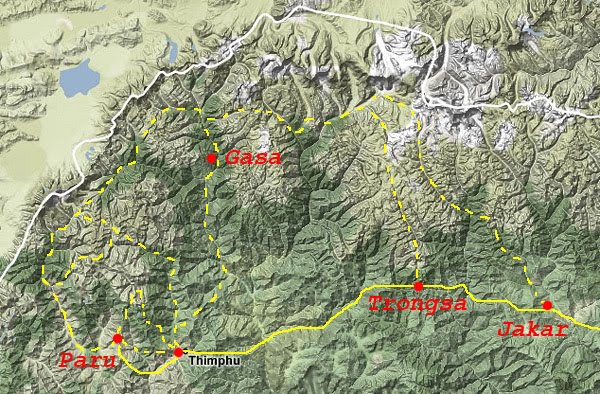
There are several good trekking routes in the Bhutan Himalayas and the Bhutanese government continues to open up new trekking routes. Some of the trekking routes are very long and will take you a month to complete(!), while other trekking routes are shorter and can be completed in a few days to a week. I’ve tried to plot some of the best and most popular trekking routes in on the map below. It isn’t an exact map to trek from, so if you’re going there, you’ll need to get your own map. This map have mountain passes, tracks and camp sites marked. Buy Now!.
The Druk Path
Between the Bhutanese capital, Thimphu, and the location of the international airport in Paro, there’s a couple of interesting trekking routes. One is pretty much a straight line between the two cities, and the other one goes up north from Paro and then down again to Thimphu. This trekking route is called the Druk Path and it’s among the most popular treks in Bhutan. The Druk Path can be completed in 4-6 days and reaches a maximum altitude of 4200 meters. On the trail you’ll pass alpine lakes with giant trouts, temples, yaks and of course a stunning mountain landscape.
The Jomolhari Trek
A slightly longer trekking route, still between Paro and Thimphu, goes up the mountain valley west of Paro, then round and down to Thimphu. There’s an option to circle back to the valley that goes down to Paro again. It typically takes about one week to complete either of these two routes.
Both of these treks (also referred to as the Jumolhari trek and the Chomolhari trek) have splendid views of Mt. Jomolhari (~7310 meters), the second biggest mountain in Bhutan and arguably the most beautiful mountain in the Himalayas! The routes also pass a couple of high glacial lakes and there’s a chance to see the fabled Himalayan blue sheep!
The short route requires you to cross the Bhonte La pass (~4890 meters) whereas on the longer, “full route”, you have to cross both the Nyela La pass (~4250 meters) and the Yeli La pass (~4930 meters).
The Long Gasa / Gangkhar Puensum Base Camp Trek (aka the Snowman’s trek)
Another trekking route that start from Paro (optional, in fact) and goes all the way up to Bhutan’s northern Himalayan mountains is the Gasa / Gangkhar Puensum Base Camp Trek. It’s a very long trekking route that typically takes about a month to complete in its full. It’s also referred to as “the toughest trek in the world” and certainly takes you to a very remote part of the Himalayas.
The rewards on this trekking route are all of the above mentioned, plus several beautiful turquoise-blue mountain lakes, hot springs in Gasa, good chances to see rare Himalayan wildlife, such as blue sheep and of course getting up close and personal with Bhutan’s highest mountain, the Gangkhar Puensum (~7570 meters). The Gangkhar Puensum has the honor of being the highest unclimbed mountain in the world today, owing to a Bhutanese ban on mountaineering. It is their belief that mountains are holy and should be kept clear of disruptive mountain climbs.
But with several 5000+ meter high passes and so many days of trekking in high altitude, this epic trekking route is not for beginners. As indicated on the map above, there are options for making this trekking route a bit smaller. If you have the time an stamina, this is really one to consider!
Other trekking routes in Bhutan There are many other options for trekking in the Bhutan Himalayas. The routes I just described are probably the 3 most spectacular, but the Samtengang Trek, the 1000 Lake trek (between Thimphu and Paro) and the Merak Valley trek (in the eastern Trashigang region) also deserves mention.
But you really need to contact a trekking agency for details. Like I mentioned in the How, when and where of Bhutan trekking, all treks have to be done through a registered trekking agency in Bhutan. Start with contacting them and asking them for suggested routes. See what your options are from a few different agencies. You can then proceed to cherry-pick, plan and arrange the trekking route that best suits YOU! That’s how it’s done…


No comments yet. Be the first!
Note: Only a member of this blog may post a comment.